


وصف لـ Trainsity Osaka
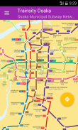
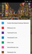
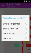
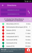
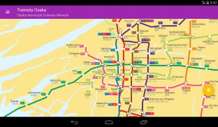
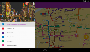
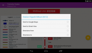
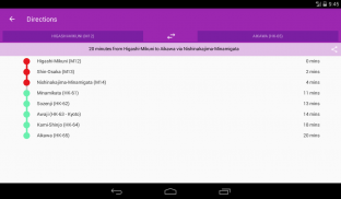
Find your way around Osaka city's subway using the high resolution vector maps of the train network. The following metro rail lines are available: Midosuji, Tanimachi, Yotsubashi, Chuo, Sennichimae, Sakaisuji, Nagahori-Tsurumi-ryokuchi, Imazatosuji, Newtram Nanko Port Town, Kita Osaka Kyuko, Kintetsu Keihanna, Hankyu Kyoto, Hankyu Senri, Osaka Monorail, and Kitakyu Namboku lines. The maps have small file size footprints but with many levels of zoom and can work offline without connecting to the Internet. Users can click the train station box labels to open Google Maps or Google StreetView, where they can use all the functions of the Google apps to visualize the surrounding area and/or perform routing for directions. There is also an offline function to calculate the best way to travel from a station to another station with a direction breakdown and timings (which may vary from the actual travelling time).
العثور على طريقك في جميع أنحاء مدينة أوساكا مترو الانفاق باستخدام عالية الدقة الخرائط ناقلات من شبكة القطار. هي خطوط السكك الحديدية المترو التالية متوفرة: Midosuji، Tanimachi، Yotsubashi، تشو، Sennichimae، Sakaisuji، Nagahori-تسورومي-ryokuchi، Imazatosuji، Newtram نانكو بورت تاون، كيتا أوساكا كيوكو، كينتيتسو Keihanna، هانكيو كيوتو، هانكيو Senri، أوساكا مونوريل، و خطوط Kitakyu Namboku. خرائط لها آثار أقدام صغيرة حجم الملف ولكن مع العديد من مستويات التكبير ويمكن أن تعمل حاليا دون الاتصال بالإنترنت. يمكن للمستخدمين النقر التسميات القطار مربع محطة لفتح خرائط جوجل أو غوغل التجول ثلاثي الأبعاد، حيث يمكنهم استخدام جميع وظائف تطبيقات جوجل لتصور المنطقة المحيطة بها و / أو تنفيذ توجيه للاتجاهات. وهناك أيضا وظيفة حاليا لحساب أفضل طريقة للسفر من محطة إلى محطة أخرى مع تفصيل الاتجاه والتوقيت (والتي قد تختلف من وقت السفر الفعلي).
Trainsity Osaka - معلومات APK
نُسخة APK: 2.1.18الحزمة: com.dom925.trainsity.osakaتطبيقات من الفئة نفسها
قد يعجبك أيضًا...


